Hello - does the plugin support the uploading of GIS files (e.g. KML) or do users need to provide the polygon’s co-ordinates?
Hey @mike10!
Thank you for your question. I wanted to clarify that the Mapbox Maps Plugin doesn’t natively support uploading GIS files like KML.
If you’re looking to draw polygons or other geospatial shapes, you’ll need to input the polygon’s coordinates manually, providing them as arrays of latitude and longitude values.
These coordinates can be used to create custom shapes like polygons, polylines, etc., on the map.
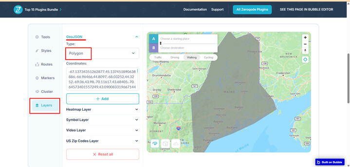
Here is an example of how this looks on the plugin demo page:
Under the Layers → Polygon Option
If you’re working with KML or another format, you would need to convert the file into GeoJSON first and then upload that into the plugin.
In case you are looking to work with KML/JSON Files on Map, there is another plugin you might want to explore - Bubble’s Google Map Extender.
Feel free to test it out on the plugin demo page and subscribe to see if it works best for your use case.
We also suggest thoroughly reviewing our demo editor page and the documentation for successful plugin integration.
Thanks again, and looking forward to your reply.
Best wishes,
Support Team
Browse all Zeroqode Plugins for bubble

1 Like
Hi @mike10,
Just following up to see if the info we shared helped clarify things regarding the Mapbox Maps Plugin and polygon setup.
Let us know if you had a chance to test it out or if you have any other questions—we’re happy to help!
Best regards,
Support Team
Browse all Zeroqode Plugins for bubble