Services Plugins FAQs

🗺 Bubble's Google Map Extender - New Plugin from Zeroqode

Hi @cbennett, thank you for your message, and thanks for using our plugin :slightly_smiling_face:

Thanks for sharing the screenshots above with the setup from your side. We will need some time to double-check with our Devs team regarding the proper functionality of the Markers with Repeating Groups. Thank you for your understanding, I will get back with an update asap.

Hi again @cbennett, thank you for your patience.

Can you please let us know more details regarding your use case with the repeating group. As we do not fully understand what is the purpose on storing the data in a repeating group and then using it with our Map Extender plugin. Please share more information regarding your use case.

Indeed, the Map Extender plugin will not work with multiple images as it retrieves only one icon/image to be displayed on the map.

Let me know if there is anything else we can assist you with.
Have a good day!

So in our app, we have a search page that allows users to search Listings (our custom data type) using some filters, and then the results are shown on the page in a Repeating Group. With the built in Bubble Map, we can use the Repeating Group as the data source so the markers automatically update when the Repeating Group updates (our data type has a geographic location and map icon image field).

However I’m trying to use Map Extender to add some GeoJSON information on this map, which means the markers no longer display and instead need to be added to the Map Extender, if I understand how it works correctly.

Is it possible to add an additional option in Map Extender where I can choose which field has my custom icon? The standard Bubble Map element has this option:

image

I think this would solve my issue and really help with the usability of Map Extender. If it can only support custom icons when the data type only has a single image field it really limits the use cases, or forces you to derive an additional data type specifically for the Map Extender markers, which I would prefer not to do.

Hi @cbennett, thank you for your patience.

We will need some additional time, to test and reproducing your use case with the plugin.

Thank you for your understanding, I will get with an update asap :pray:t3:

Hi again @cbennett,

In regards to your setup, I have discussed with our Devs team about the possibility to recreate your use case. Therefore, I would recommend you to store the data about the markers from the RG inside the database, afterwards retrieve the stored data and use it to display the markers on the map.

Another workaround, when using GeoJSON you can add ‘points’ to the map that will be displayed in based on the options that users will select.
Please check the below articles for reference -

As well, I found this tool where you can generate the JSON code - https://geojson.io

Hope this helps.
Let me know if there is anything else I can assist you with.

Hello,

Amazing plugin! Thanks for it! I have one question, is it possible to check if some object from my database which I tracking live is out of some zone which I previously set by GeoJSON?

For example I set zone for whole New York, and when one of tracking object get out of New York I will receive notification about that?

Also could I track live position of different object?

Regards
Kamil

Hello @ktarczynski, thank you for your message, and thanks for your interest in our plugin :slightly_smiling_face:

Unfortunately, the Map Extender plugin will allow to draw and save the polygon on the map, though it does not have an option to track the user of the map.
I would recommend you to check instead our MapBox plugin that has the option to draw the polygon area on the map and to locate the user (tracking objects) when they are outside the polygon (New York).
You can test this function on MapBox’s demo page.

  1. Allow the app to get your location - you will see the marker/blue point with your location
  2. Draw the polygon on the map
  3. Try to move the polygon outside the range of your location (point) - this will trigger an alert that will appear on the page
  4. Check the related actions on the demo page
  5. Read through the documentation of the plugin to get familiar with its functionality

Let me know if this helped, or if there is anything else I can assist you with.

Sounds nice, but If I got X objects to track on, which I cannot look all the time I could do this in backend?

I mean, I would like to get an email when one of the object, when I dont look on map or even dont have app open in browser get out of assigned area? I think that would be littly tricky to accomplish.

Hello @ktarczynski,

Sure, you can track multiple users at the same time when using the MapBox plugin. I would best recommend you to check the plugin’s documentation and the demo page to get familiar with it.

That is also possible to achieve with the plugin and the Bubble functionality.
It is needed to set the current user’s position as a marker, then you can use the ‘Get Markers in Drawed Polygons’ action. The last point is to set a condition that will be triggered once the user is out of the polygon. You can do that by adding an event ‘Do when condition is true’ that will be responsible for when the user will be out of the polygon and will send an automatic email.

Let me know if you sorted it out, or if you got any other questions.

Hi All!

We have pushed a plugin update, that has added an earlier requested feature, namely, the possibility to show a custom marker info popup.
Extender popup

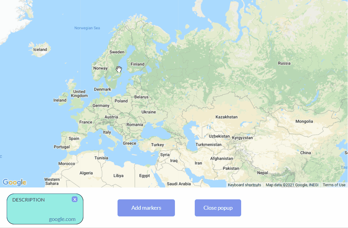
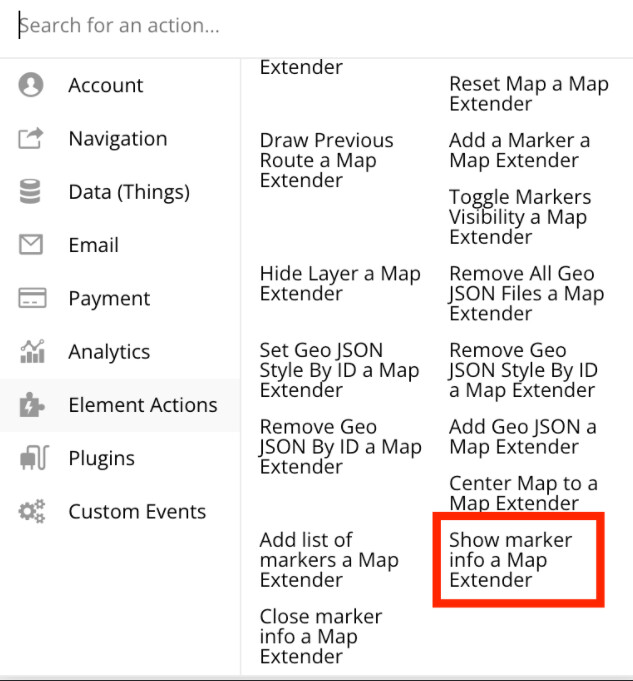
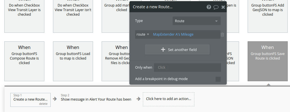
It is ensured by two actions:

In this action, we can address an earlier created group (which will be a popup for displayed information).
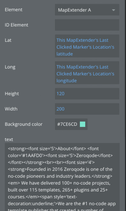
Or we can create a popup, setting the height and width of the desired popup, in which we can upload the text or HTML, to display the required information

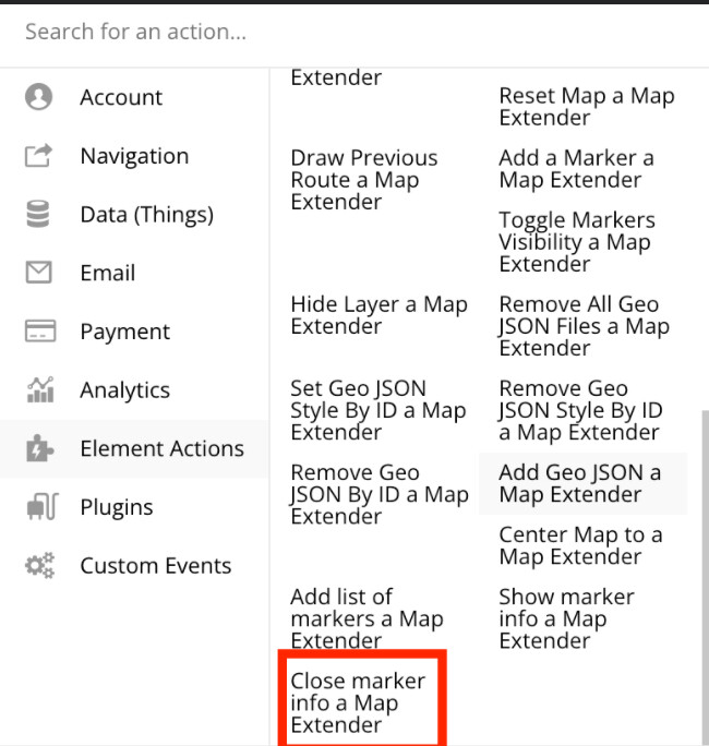
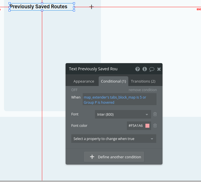
  • and Close marker info - this action can be attached to any button or group, to close the displayed information popup.

To check changes, please upgrade your plugin to the latest version (Version 1.8.0: Fixed CORS error. ) and give it a try.

In case of related questions, you know where to find us :blush:

Have a good week ahead :wink:
Regards,

1 Like

Can someone explain how to save and load routes/directions? It looks like the demo isn’t working correctly.

Hello, @dallasb86
Thanks for reaching out.

I’ve tested our Demo Page and the mentioned functionality works properly. You can easily save addresses and use the saved route :slightly_smiling_face:

Please find below the screenshots with the workflow for the “Save route” action:


Note that you can use Distance, Latitude and Longitude of the current location and etc, instead of Mileage.

Please try it and let me know about the result.
Best regards,

Thank you, that helps a lot!

When creating the route field for the Route data type, what should be selected for the field type?

Hi @dallasb86, thanks for your question.

Please use the “text” data type for route field.
image

Hope it helps. If any other questions appear, just drop a message here :wink:

Have a nice week!

Regards,

Hey, guys! Thank you for a great job!
Wanted to check with you, is this Plagin capable to navigate users like google maps, maybe even with voice notifications? If not do you have any plugin which I can use for this?

Hi @IvanTakeshenko,
Thank you for your message.

The Google Map Extender Plugin offers the ability to enhance the default Map component in Bubble by incorporating additional functionalities. The majority of these features are highlighted on the live demo page of the plugin. Make sure to explore this resource along with the accompanying documentation.

You can Track current user position in real time if by that you intend to navigate users, but there are no voice notifications, unfortunately.

Another plugin you can also consider is the MapBox Maps Plugin, you can find it here: MapBox Maps Plugin for Bubble | Zeroqode

In case you have other product-related questions, feel free to contact me.
Best regards,

Okay, thank you for your response!

2 Likes

Hey everyone! :raised_hands:

Exciting news! We’ve updated the demo page for our Google Map Extender plugin. For ease of reference, we’ve included new use-case scenarios:

  • create a new marker

  • add marker

  • show marker

  • hide marker

  • edit marker

  • delete marker

  • context menu (right-click on the map)

Additionally, the Google Map Extender Plugin has received significant updates this month:

  • New in Version 1.46: Updated action - “Add the list of markers”

  • New in Version 1.48: Updated marker and route actions.

  • New in Version 1.52: Added features left & right clicks on the map

For any further questions regarding the plugin, or suggestions to enhance it, don’t hesitate to email us at support@zeroqode.com or discuss on our forum. We’re always here to assist.

Best regards, :slight_smile: