Services Plugins FAQs

Google Maps Extender Plugin add markers not working

Hi there,

I have a list of locations in my database with latitudes and longitudes as well as reverse geocoded addresses derived from the lat/longs using Google’s reverse geocoder.

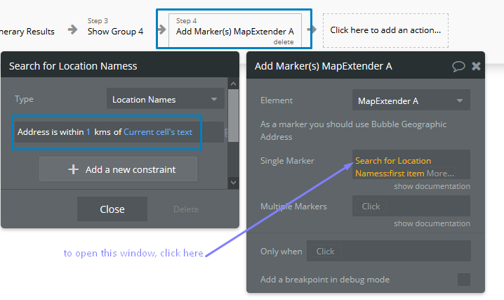
I know the addresses are valid because when I use them as origins, destinations, or waypoints with the Google Maps Extender plugin, the map generates the correct location.

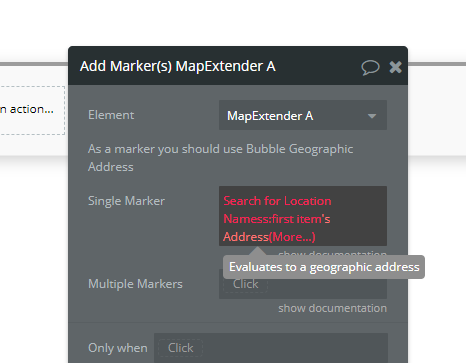
However, if I try to add a single or multiple markers to the map from the addresses in my database using the same Google Maps Extender Plugin, it doesn’t work.
App%20Error%20Calc%20address%202

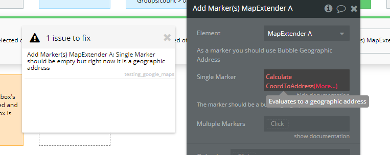
I have also tried calculating the address using the lat and long in my database and it still doesn’t work:

My app is https://route-manager.bubbleapps.io/testing_google_maps

Additionally, you cannot add the text location generated by the fastest google places autocomplete.

Hello, @harrisonalley! Thanks for reaching out.

Your request is under investigation. I will get back to you when there any useful information appears.

Thank you for understanding.
Regards,

Thanks, @kate. Any help on this would be great since this seems like a critical function of the plugin that’s not working for me and it’s necessary for what I’m trying to build.

I appreciate it!

@harrisonalley,

Our team has investigated your issue and the most probable root cause is in the missing/mismatching the Marker Type property. This is the part of the MapExtender element (screenshot - here you can see our test marker type “testeCH”).

As a solution, you can try this:

  1. Create new data type in your database (Data > Data types > New type) with the following parameters: http://prntscr.com/s8jqzt
    Use some handy name like “Geo address” or so. We used the name "testeCH’ for test purposes.

  2. Create a table in your database, where you will list the locations ( Data > App Data > New view), set the same data type, which you created on step 1 http://prntscr.com/s8n3vq

  3. Set the Marker Type to your MapExtender element http://prntscr.com/s8jtli

  4. Set the Marker Type in your Workflow Action http://prntscr.com/s8juj1

This solution should work for both Single and Multiple markers (Action properties). Could you please check and confirm?
Regards,

Hi @kate

Thanks so much for your response. I see that your solution requires creating a table in your database with only one data type (geographic address) and referring to that table.

To answer your question, this does technically work in my app to produce a map marker.

However, I’m confused as to why I can’t simply set the Marker Type in my MapExtender element to geographic address, and have my marker type in my work flow evaluate to a single (or list of) geographic address(es) already stored in a table in my database with other columns.

This is how I have currently set up my app and it’s not working.

I see that the only MapExtender on your demo page for this plugin that uses the Marker Type property refers to a table in your database with only one geographic address field (just like how you recommended in your instructions above).

However, I don’t think this is practical for most people. In other words, I think most users would want to be able to refer to a geographic address in any table instead of having to create a separate table with only one geographic address field.

Furthermore, it seems like you should also be able to add the text location generated by your fastest google places autocomplete plugin without having to first store it in a table in the database with only one data type: geographic addresses. (This is a feature I would like to employ.)

I have added support@zeroqode.com as a collaborator to my app: https://route-manager.bubbleapps.io/testing_google_maps

@harrisonalley,

Thank you for your reply and for adding us as a collaborator of your app. I see your problem (concerning the list of geo addresses stored in your database, not a single one) and will do my best to research and help with it.

I will get back to you asap I have any useful update on your request and after your app investigation. I rely on your understanding :pray:
Regards,

1 Like

@harrisonalley,

Our team has found a solution, that allows you to use one of the locations, listed in the table, via the Simple Marker option (without a need to create separate tables). Take a look at how it can be done:

  • you already have your table with geo adresses, called Location Names;
  • in MapExtender A set the Marker Type - the table with your locations (Location Names);
  • in Single Marker set the Search for {your table with locations name}s:first item;
  • add the constraint to the searching action: "Address is within 1 kms of {the name of the element, that triggers the map parker to appear}. You may play around and set the different values for this parameter. We’ve tested within 1 km :slight_smile:

Thus, when you click on the single checkbox, the location of that cell should be displayed on the map. Like on the video: https://www.loom.com/share/2ec7611daa0d415da0e456fc8923f91b

I left your app (test page) in the same condition you have provided it to me. So you can check on your own if this a workable solution, and let me know.

Thank you for your patience.
Regards,

1 Like

@Kate, thanks for your efforts.

That’s an interesting work around.

However, it doesn’t work in all circumstances, particularly when I have a photo location that has a title which doesn’t correspond to a searchable location in maps.

For instance, “West Village Murals” in the urban category in Dallas won’t show up on the map.

I have found other locations besides this one that also don’t work.

@harrisonalley,

I’m sorry that this solution is not working with your app. I suppose it is that because of the image elements you have in your table.
I agree that this solution might be not very helpful in your case. But it is workable if you need to show up only the map location. Perhaps your case requires more time for investigation and set up in accordance with your app logic. I hope you will find a workable solution, which will fit perfectly to your app.

Apologies for not being very helpful :pray:
Regards,

Do you think you all will fix this issue in future updates?

@harrisonalley,

I’m afraid, it is not a bug, as you might consider. Thus, there is nothing to be fixed, since the core features of the plugin are workable.

The proper plugin work (adding single and multiple markers to the map) requires the setup, where the data type, of the table with locations, should be a geographical address.

I suppose, there is not a problem to create an additional table with images and to set the workflow which will be retrieving those images at the time you need.

Thank you for understanding :pray:
Regards,