Services Plugins FAQs

🗺 Mapbox Maps - Total revamp of one of the most popular Bubble plugins from Zeroqode

Hello, Zeroqoders! :grinning:

We are so excited to announce that we have released an updated version of our Mapbox Maps plugin that we have been working on so much. :tada:

MapBox

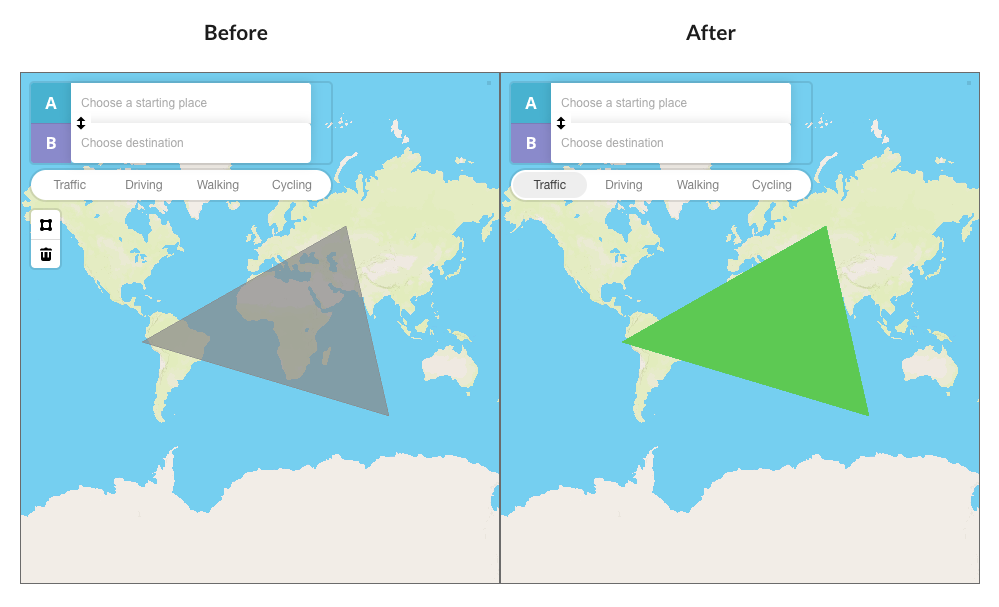
We have tried to include the maximum number of requested features. So, here they are:

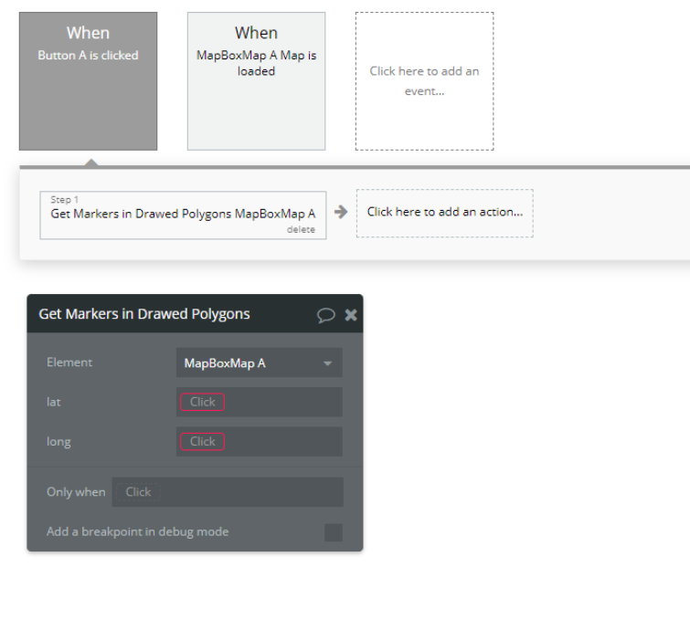
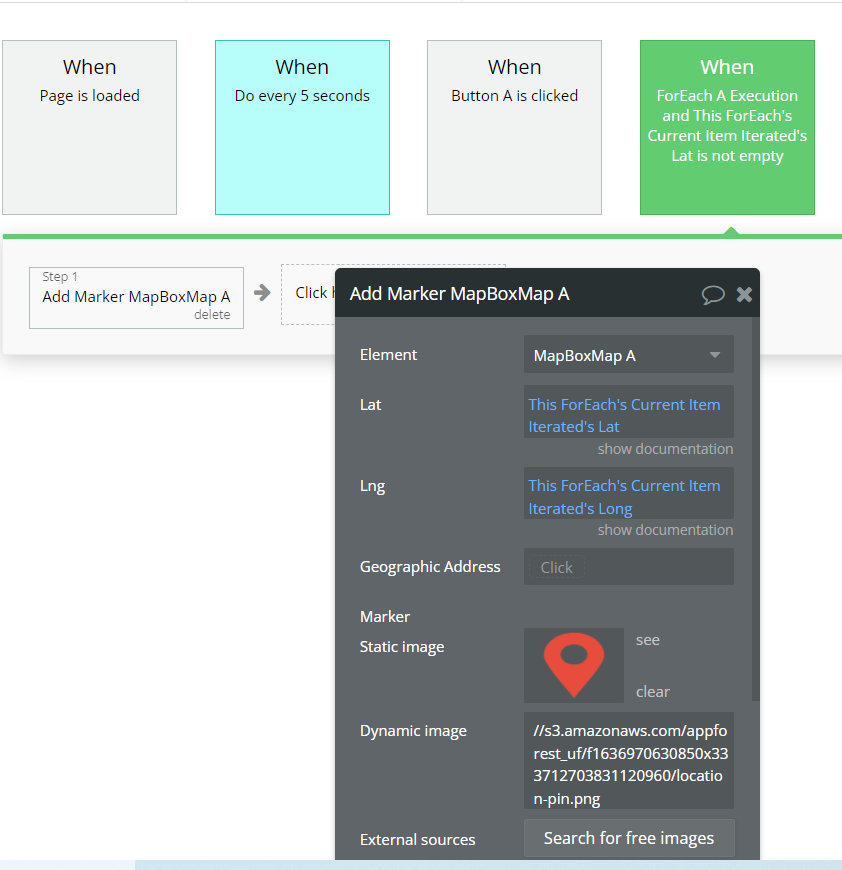
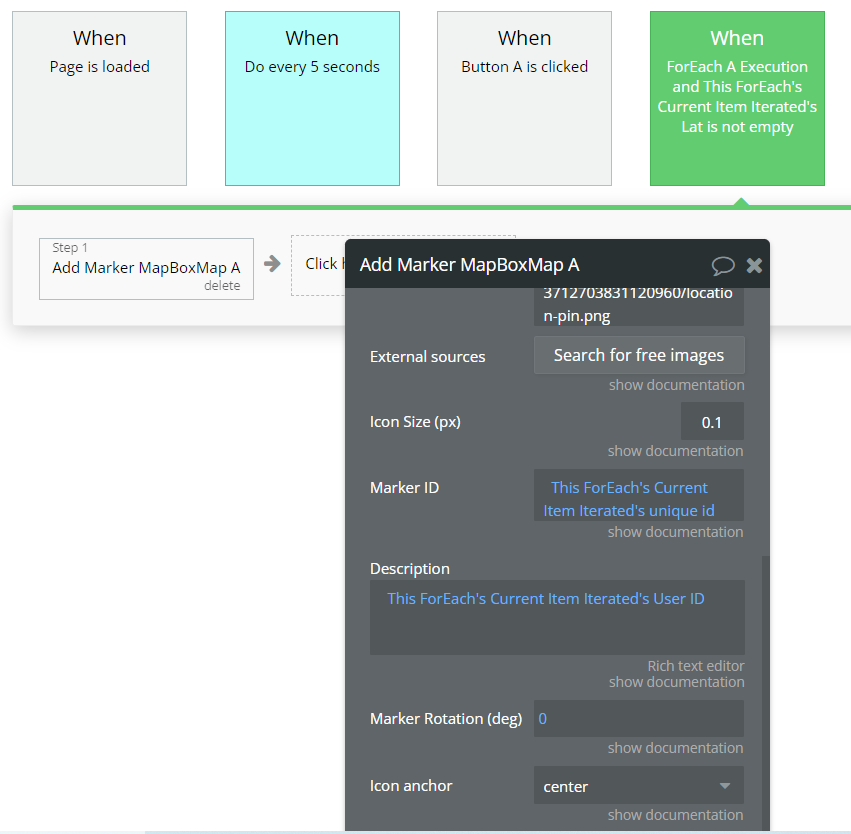
  • adding draggable markers;

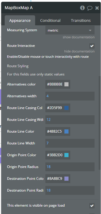
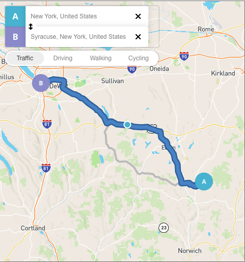
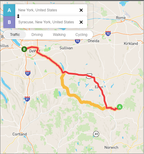
  • an ability to measure distances;

  • the full screen map view;

  • geocoder inside and outside the map;

  • an ability to place the geocoder input outside the map;

  • animate a point on the route, a camera on the way, and much more;

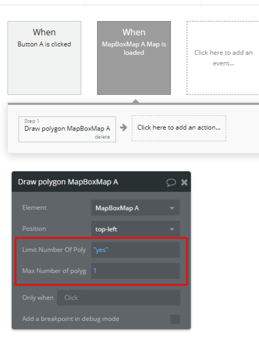
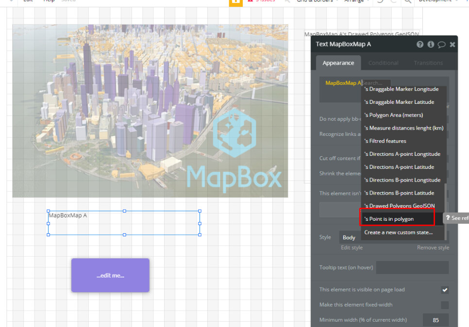
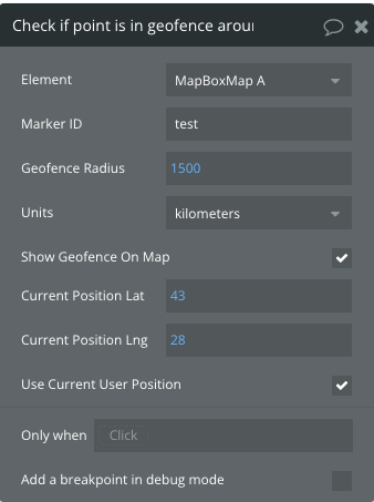
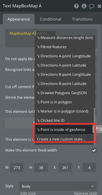
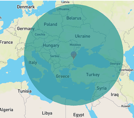
  • an ability to draw a polygon and calculate its area;

  • enable and disable map rotation;

  • an ability to display a popup on hover;

  • an ability to filter features within map view;

  • adding the video;

  • adding 3D terrain to a map;

  • accepting coordinates as input to a geocoder;

  • an ability to change a map’s language;

  • an ability to change the case of labels

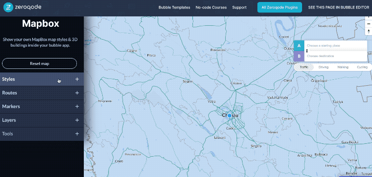
Go ahead and try it out on our new Live Demo: https://zeroqode-demo-08.bubbleapps.io/mapbox-map

DEMO & DOCUMENTATION:

Hope you’ll like it :wink: If you have any questions or suggestions - we are always here to help you out!

Anastasija Volozaninova

Executive Assistant @ Zeroqode

#1 Bubble Publisher and Developer

logo-icon-S-circle

100+ Bubble Templates

25+ Bubble Courses

250+ Bubble Plugins

20+ Bubble Building Blocks

Convert Web to iOS & Android

No-code Development Services

Zero Code Conference Replay - watch all the no-code industry leaders share their expertise and insights on building and scaling startups without code

1 Like

@Anastasija

Hey! Hope you are well!

Just hoping i could ask like 3 lil questions.

Any polygons created on map, is there a state to pass the polygon lat/long (or geojson?)

Is there a way to limit amount polygons that can be created? (example max 2 polygons, in the one session)

Lastly, is there an action to check if a location pin (lat/lon) is within a polygon?

Cheers!

Hi @haydos99, thanks for your questions.
Allow me to check them internally with the developer team, and come with a reply asap.
Thank you for understanding.
Regards,

Hi @haydos99, thanks for your patience.

Unfortunately, the current plugin functionality doesn’t provide such options. Sorry for the inconvenience.
We will check how feasible it will be to add the requested features to the future plugin update, thank you for suggesting it.

Please let me know I can help with any other plugin-related questions.
Regards,

1 Like

Thank you for upgrading the plugin. However I’m having trouble with the Default Map Position.

I have been using version 1.29.0 of your plugin, which has successfully loaded my custom Mapbox style, with the Center of the map at the Default Map Position as specified in Mapbox Studio.

Once I try upgrading the plugin to 1.30.0 or anything newer, the map loads with the Center at (0,0) off the coast of Africa rather than where my map features are.

Am I doing something wrong? With the upgraded plugin, how do I set the map to center on the Default Map Position as specified in Mapbox?

Thank you Zeroqode

I am having a second issue – I can’t get Mapbox elements to vertically resize in order to be vertically responsive. I’m using the Zeroqode plugin Move or Resize Elements but it is not working for Mapbox elements. It works for other elements, so I think the problem is with the Mapbox plugin.

I posted my issue with screencast here

Hi @gar34, thanks for your messages.

Please use the corresponding action, and indicate required coordinates (47\28 only as example):

Please let us know if it works as required or any other support is required.
Regards,

In a short time, I will reply to it in the indicated thread (upd: replied on 06.09.21).

1 Like

Hi @haydos99, thanks for your patience.
We have pushed a plugin update, that has added the required features (limit the number of polygons, check if location pin is within polygon).

To check changes, please upgrade your plugin to the latest version (Version 1.35.0: added new functions related to the polygon drawing tool) and give it a try.

See the examples:

Summary


Please let me know if we can help with anything else related to our plugin.
Regards,

Hello Zeroqoders :hugs:

We pretty often have met the question: “How to track third party users movement through our insert a name plugin

So, we would like to share a simple setup, which makes it realizable through the Mapbox plugin.
Please note that to implement it, besides the Mapbox plugin, we’ve used the “Ultimate Toolkit” free plugin, namely the For Each element.

See the following screenshots for setup guidance:

  1. Create a data type

  2. Place the For Each element on page (and Mapbox element ofc).

  3. Setup the workflows:

Summary


Hope the provided description will help you with implementation of your ideas!

Regards,

1 Like

Hello Zeroqoders!
There are some good news for you and @ngocquanghn & @cesar.

We have pushed a plugin update, that has added some of the earlier requested features, namely:

Before:

After:

  • Create line customization:
    This feature allows you to make the drawn area colored.

  • Geofence
    This feature allows you to determine if the marker is in the geofence. Provides the possibility to check through a state if the clicked point is within geofence or not (Cliked Line ID).
    image


    image

To check changes, please upgrade your plugin to the latest version (Version 1.42.0: Added styling options and improved detection tools) and give it a try.

Merry Christmas :christmas_tree:

Regards,

2 Likes

And more good news to Mapbox fans!!!

We’ve pushed a plugin update, that has added the possibility to create and style clusters.

The source GeoJSON can be generated on any specialized platform (for example https://geojson.io/), where you can also include information that will be displayed on the field shown on click and field that returns as a state.

To check changes, please upgrade your plugin to the latest version (Version 1.43.0: added new action “Create Clusters”) and give it a try.

Regards,

2 Likes

Hi,

Is it possible to cluster markers? so markers that are close to each others as you zoom in or out gather into one single circle with a number on it like shown below:

image

Thank you
Gil

Hi @gil06000, thanks for reaching out.

Sure thing, this feature has been added in one of the previous updates (Version 1.43.0).
Here is a small setup example of how it works: zeroqode-demo-08 | Bubble Editor

Hope the provided information will help. Please let me know if there is anything else that I can help with.

Regards,

Thank you Serg for your answer.

Looking at this demo I notice a Source GeoJSON. Does this feature require to have such a source to make the clusters to work?

My goal is simply to add locations, quite a few, on the map which will be added manually by the users by just clicking on a location to add it on the map and then see all locations from all users in clusters as the user zoom in and out. The clusters should be automatic as soon as the map opens and show all locations.

is this easy to implement (the cluster part)?

Thank you
Gil

Hi @gil06000, thanks for your reply.

Yes, for guidance, please see the description on the forum post above. Create and save the map in required GeoJSON format and use the obtained link.

I’m afraid that the current plugin functionality would not support such a flow (dynamically add/delete locations on the map).
The developer team will check how feasible would be to add such a feature in future plugin updates, thanks for suggesting it. In case any news will appear in this regard, I will let you know asap.

Regards,

Hi,

That is too bad because I like some functionalities such as the possibility to add a draggable marker, center the map, plus others and to have a serious support.

Currently there is the free Leafy Map on Bubble plugin (I am sure you are aware of this one) that offers this possibility to zoom in and out with clusters when adding new locations. There is no GeoJson to add just to check a box for this option.

I hope you will be able to add this functionality to your plugin.

Let me know if you do.
Thank you again for your answer.
BR
Gil

Please let me

Hi @gil06000, thanks for your reply.
I’m afraid so far there are no estimations or time limits on when this feature would come to live. Sorry about that.

In any case, if there will be any news - you will get them first :slightly_smiling_face:

Let me know if in meanwhile, there is anything else about our plugin that I can help with.

Regards,

Dear Bubblers, here are some good news!

Update 1.55.0. has adapted our Mapbox plugin to the new responsive engine!

Please upgrade the plugin to the latest version, refresh the application and give it a try :hugs:

Also, you can check new responsive on our updated Demo page!

Regards,

1 Like

Hi @Serg – I’m always happy to see Zeroqode continuing to improve this excellent plugin!

One request:

It is great how the plugin reveals the state “Map Center Lat” and “Map Center Long”. But unfortunately the plugin does not also reveal any of the following:

  • Map Current Zoom
  • Map Current Bearing
  • Map Current Pitch

Could the plugin be improved to also reveal those states?

Thank you very much

Hi @gar34, thanks for your appreciation and provided suggestions :hugs:

I’ve added them to the plugin development roadmap. The developer team will check how feasible would be to add them in future plugin updates.
Once any news will become available, we will let you know asap.

Regards,